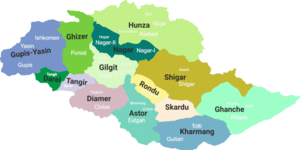
The Ghizer District (Urdu: ضلع غیزر) is a district of Pakistan-administered Azad Kashmir in the gilgit baltistan region. It is one of the 14 districts of the Pakistan-administered territory of Gilgit-Baltistan. The former Ghizer District that existed from 1974 to 2019 spanned the entire upper Gilgit River Valley (also known as the Ghizer River Valley). In 2019, the former district was divided into the Gupis-Yasin District in the west and the present, smaller Ghizer District in the east.

Geography

The Ghizer District is bounded on the north by the Upper Chitral District of Pakistan's Khyber Pakhtunkhwa Province and the Wakhan District of Afghanistan's Badakhshan Province, on the east by the Hunza District, the Nagar District, and the Gilgit District, on the south by the Tangir District, on the south-west by the Darel District, and on the west by the Gupis-Yasin District.
The highest peak of Ghizer District is Koyo Zom (6,871 m) (Hindu Kush Range), which lies on the boundary between Ghizer District and Chitral.
Some of the main places in the district are Koh-i-Ghizer, Ishkoman and Yasin valleys. Other places include Gupis, Chatorkhand, Imit, Pingal, Shahmaran and Utz.
Some of the passes in the district are:
- Bichhar Pass (on the boundary of Ghizer and Gilgit Districts)
- Chillingi Pass
- Hayal Pass and Naltar Pass (on the boundary of Ghizer and Gilgit Districts)
- Kalandar Pass
The main river in the district is the Gilgit River. The other tributaries include the Qurumbar River, Phakora River, Hayal River, Singul River and Yasin River, Phander river tributary which also joins the main stream at different points.


